
Courtesy image.
FLAGSTAFF — Coconino National Forest fire managers will resume spring prescribed fire plans following an unexpected delay due to precipitation across northern Arizona.
“Last weekend’s snow and rain is an example of why we always frame our prescribed fire plans as ‘tentative’ until we can conduct our pre-project test fire,” said Jason Clawson, Coconino National Forest Fire Staff Officer.
Successful prescribed fire requires ideal conditions. “Hazardous fuels” – including pine needle accumulation, dead and down trees and decaying plant matter on forest floors – need to be dry enough to burn at a low rate of intensity, but not too dry as to burn hot and fast.
Planned prescribed fire projects will always be canceled if weather conditions – such as temperature, wind and humidity – do not meet the criteria outlined in the burn plan.
More information about the relationship between prescribed fire and weather is available at coconinonationalforest.us, and the latest updates regarding prescribed fire plans on the Coconino National Forest can be found at inciweb.wildfire.gov.
Fire managers always start each prescribed fire with a test fire performed right before full ignitions, to ensure conditions are ideal to proceed with prescribed fire plans.
“Conditions were just too wet to get the ideal results from any attempted ignition,” Clawson added. “If we attempted to burn earlier this week, we wouldn’t have had the results we were looking for.”
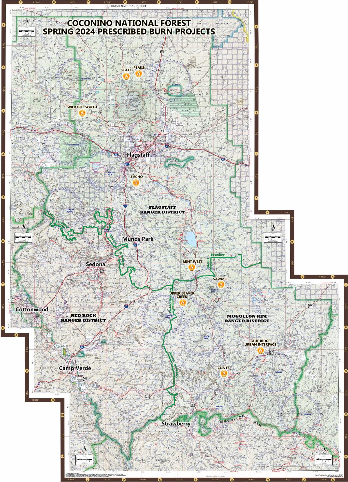
Projects planned for next week include:
Horseshoe (Peaks project area)
(Flagstaff Ranger District) (project map)
- Tentative dates: May 6 and May 7, 2024 (Monday and Tuesday).
- Duration: Two days.
- Location: 15 miles north of Flagstaff: North of the San Francisco Peaks and west of Highway 89.
- Size: 3,963 acres.
- Type of burn: Broadcast, maintenance. Maintenance burns usually mean wildfire has recently been through the area, which tends to mean less smoke since forest fuels will not be as thick or built up over time. Broadcast burning means firefighters use tools, such as drip torches, to move fire across large swaths of land.
- Smoke impacts: Smoke is expected to travel to the northeast during ignitions. Possible impacts will be felt along Highway 89. Smoke may settle in low-lying areas overnight.
- Why: This prescribed fire will reduce fuel loading north of Flagstaff, thus lessening the risk of catastrophic unplanned wildfire during times of critical fire weather. This project also reintroduces fire into a fire-adapted ecosystem.
- Notes: There are no closures anticipated. A helicopter may be used during this project to assist with aerial ignitions.
Blue Ridge Urban Interface
(Mogollon Rim Ranger District) (project map)
- Tentative dates: May 7 through May 10, 2024 (Tuesday through Friday).
- Duration: Four days.
- Location: 8.5 miles northeast of Clints Well: Near the Mogollon Rim Ranger Station
- Size: 1350 acres.
- Type of burn: Broadcast, maintenance.
- Smoke impacts: Smoke may impact Highway 87 and the Blue Ridge subdivisions, as well as possible impacts to the Winslow and Holbrook areas. Due to recent land treatments, smoke impacts are expected to be light in duration.
- Why: This project will continue 20 years of routine fire treatment in the Blue Ridge area to protect nearby infrastructure and maintain landscape health.
- Notes: There are no closures anticipated. However, Arizona Trail hikers are advised to avoid the project area.
3Echo (3E)
(Flagstaff Ranger District) (project map)
- Tentative dates: May 8 through May 10 (Wednesday through Friday).
- Duration: Three days.
- Location: 5 miles south of Flagstaff: Between Lower Lake Mary and Mountainaire.
- Size: 4,622 acres.
- Type of burn: Broadcast, maintenance.
- Smoke impacts: Smoke will be highly visible from the City of Flagstaff and all surrounding areas. Smoke is expected to travel in an east or northeast direction during ignitions, and possible daytime impacts will be felt on the east side of Flagstaff, along Interstate 40, at Walnut Canyon National Monument, along Lake Mary Road south of Flagstaff and in the Continental community. Smoke may settle in low-lying areas overnight.
- Why: This prescribed fire will reduce fuel loading south of Flagstaff, thus lessening the risk of catastrophic unplanned wildfire during times of critical fire weather. This project also reintroduces fire into a fire-adapted ecosystem.
- Notes: There are no closures anticipated.
Horseshoe (Wild Bill project area)
(Flagstaff Ranger District) (project map)
- Tentative dates: May 11 and May 12 (Saturday and Sunday).
- Duration: Two days.
- Location: 14 miles northwest of Flagstaff: 4.5 miles north of Bellemont
- Size: 3,960 acres
- Type of burn: Broadcast, initial entry. Initial entry burns mean wildfire has not been through the area in a very long time and thus results in thicker smoke due to a large amount of forest fuels being present that must be burned.
- Smoke impacts: Possible smoke impacts will be felt along Highway 180 and in and around Kendrick Park during the daytime. Possible smoke impacts may be felt in the Bellemont area and along Interstate 40 overnight.
- Why: This prescribed fire will reduce fuel loading in the project area. Additionally, it will provide protection to the Upper Rio de Flag watershed, which will reduce the ensuing risk of catastrophic wildfire and subsequent flood damage to the City of Flagstaff.
- Notes: There are no closures anticipated.
In addition to planned prescribed fire projects, the Coconino National Forest will continue beneficial land treatment methods as part of the Wolf Fire: a lightning-sparked wildfire located 3 miles northwest of Clints Well.
An increase in fire on the Coconino National Forest’s landscape is part of the Forest Service’s 10-year Wildfire Crisis Strategy.
During prescribed fire, smoke will be visible from several areas across the forest. Please refrain from contacting dispatch or 911 to report prescribed fires so lines can remain open for emergencies.
Prescribed fires are also subject to approval from the Arizona Department of Environmental Quality (ADEQ). The public can view approved prescribed fire projects on ADEQ’s website at smoke.azdeq.gov. Coconino National Forest fire projects begin with the designator “COF.”
Fire managers take air quality concerns seriously and are trained to minimize smoke impacts to the greatest extent possible. The Coconino National Forest will continue to coordinate closely with partners to keep communities informed about projects and potential smoke. More information is available at airnow.gov